Ireland is a sovereign state which covers approximately five-sixths of the island of Ireland, off the coast of north-west Europe. The state's constitutional name is Ireland and this is how international organisations and residents usually refer to the country. It is a member of the European Union, has a developed economy and a population of almost 4.6 million (2011 census). The remaining sixth of the island of Ireland is known as Northern Ireland and is part of the ► United Kingdom.
Is stát í Éire ar an gcuid is mó d'oileán na hÉireann, amach ó chósta thiar-thuaidh na hEorpa. eIs le Tuaisceart Éireann, atá laistigh den Ríocht Aontaithe, an chuid eile den oileán. Éire an teideal oifigiúil atá ar an stát as Gaeilge – leis an gcur síos oifigiúil (Poblacht na hÉireann). Cé gur fhan an Phoblacht neodrach le linn an Dara Chogaidh Domhanda agus cogaí eile ó shin, is ballstát de na Náisiúin Aontaithe agus den Aontas Eorpach í, ach ní dheachaigh sí isteach in ECAT, ar eagraíocht míleata é.
Short name
Ireland
Official name
Ireland
Status
Independent country since 1916, recognized 1922, member of the ► European Union since 1973
This section holds a short summary of the history of the area of present-day Ireland, illustrated with maps, including historical maps of former countries and empires that included present-day Ireland.
Ireland in the Ice Age
Ireland in 1014
Ireland in 1300
Ireland in 1450
Partitioned Ireland, 1920
Partitioned Ireland, 1920, with capital cities
Development of protestantism in Ireland
Old maps
This section holds copies of original general maps more than 70 years old.
Map of Eryn (Ireland) by Ortelius, 1573
Map of the British Isles, 802 AD
Ethnic and linguistic maps
The Gaeltacht regions
insular Celtic peoples
Economical maps
Income distribution
Population density (2002)
Satellite maps
Satellite map
Notes and references
General remarks:
The WIKIMEDIA COMMONS Atlas of the World is an organized and commented collection of geographical, political and historical maps available at Wikimedia Commons. The main page is therefore the portal to maps and cartography on Wikimedia. That page contains links to entries by country, continent and by topic as well as general notes and references.
Every entry has an introduction section in English. If other languages are native and/or official in an entity, introductions in other languages are added in separate sections. The text of the introduction(s) is based on the content of the Wikipedia encyclopedia. For sources of the introduction see therefore the Wikipedia entries linked to. The same goes for the texts in the history sections.
Historical maps are included in the continent, country and dependency entries.
The status of various entities is disputed. See the content for the entities concerned.
The maps of former countries that are more or less continued by a present-day country or had a territory included in only one or two countries are included in the atlas of the present-day country. For example the Ottoman Empire can be found in the Atlas of Turkey.


 Province of Connacht
 Province of Leinster
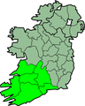 Province of Munster
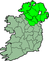 Province of Ulster


 Counties of Ireland
 County Antrim
 County Armagh
 County Down
 County Fermanagh
 County Londonderry
 County Tyrone
 County Carlow
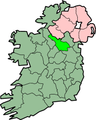 County Cavan
 County Clare
 County Cork
 County Dublin
 County Donegal
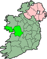 County Galway
 County Kerry
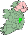 County Kildare
 County Kilkenny
 County Laois
 County Leitrim
 County Limerick
 County Longford
 County Louth
 County Mayo
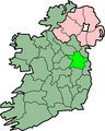 County Meath
 County Monaghan
 County Offaly
 County Roscommon
 County Sligo
 County Tipperary
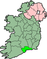 County Waterford
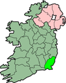 County Wexford
 County Weastmeath
 County Wicklow


